I am going to do this post slightly different than the ones that came before. Instead of just posting my journal entries I will write it in more of a story format. I have created a separate page to add just the journal entries. I am hoping to be able to add more to them with hindsight.
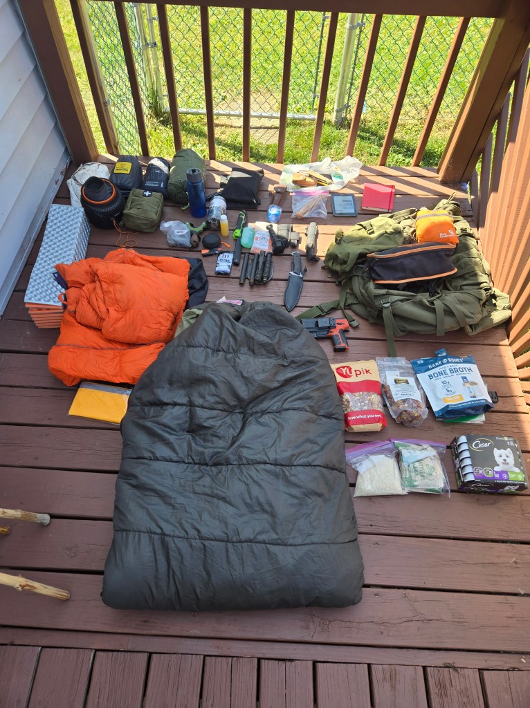
I was dropped off at the beginning of the Laurel Highlands Hiking trail at 930 on a Monday. My bag weighed in at 56 pounds and Taz even came with us to say goodbye. He didn’t seem very upset by this. I think he loves hiking but also likes to be able to lay on a bed or couch afterwards. Tents are not his thing. The day was pretty hot close to 82 and the sun was shining. I felt pretty good, I have been training and hiking a good deal more and the weight of my pack no longer felt too uncomfortable. Too think that a mere month ago I was struggling with this same amount of weight and was about to start on a 70 mile adventure with it.
I felt really good, the day was bright and beautiful and the trail was before me. I decided to start at this end due to it being the hardest part of the trail with the steepest hills. I figured the rest of the trail would seem easy by comparison. Hard is definitely the right word to describe this part of the trail. The first 2.6 miles you head up to the overlook, to get a beautiful view of river, hills and changing fall colors. The rock outcropping at this point is one I visit quite often. I like to sit at the edge and feel the breeze while taking in the view. I picked up a new walking stick along the trail and decided to take a littel bit to whittle it down to a good size and shape. Also I like to keep my hands busy while I rest, otherwise I am likely to get up and start hiking again after a minute or 2. After reaching the height I started to head back down the other side of the mountain. Its about 4 miles to where the shelter area is and I plan to make it at least 10 by the end of the day. I stopped again after mile 5 the trail gets a little narrow and you go up and down steep hills for a bit so I decided it was ok to take a little break every couple miles. There are so many animals out, I am pretty sure Taz normally scares them away but it would seem without his presence I am not scary enough for them to hide away from. Fortunately for those little buggers I brought over 2 weeks worth of food for this trip. I figured It may take 10 to 11 days and I’d rather have too much food than not enough. I actually met another hiker they were on their way back from the shelter area, I was surprised since it is Monday and I didnt anticipate seeing anyone to be honest. That just goes to show you I am not the only wilderness weirdo out there. After starting again I quickly came to the shelter area sign, Go left to sleep in a shelter, and right to continue the journey! I went right, straight up the hill for about 2 miles. This hill was incredibly steep with out any of the customary switchbacks one would expect on a trail. It was intesnse and terrible I felt like my heart was gonig to explode and my legs shook with every step. I had to take breaks every 5 minutes and thought about turning around or trying to find a way to camp on the hillside. However, I persevered and made it to the top. I can not even begin to explain how bad of an incline this is. and for it to go on for 2 miles is nearly unbearable. This is one of the reasons why people usually start at the other end. this is absolutely a downhill, hill. At the top I took a lengthy break on a rock outcropping that sat on the side of the hill giving me a nice overlook of the forest. After a long break to catch my breath and regain some strength in my legs I decided to move on till the 10 mile marker. It was mostly down hill after that and the trail lead through some beautiful rock formations which I took the liberty of climbing on for a bit. By the 10 mile I was exhausted and ready to set up camp. I scarpered off the trail and headed a good 400 feet into the woods to find a good spot. I cleaned up the area of sticks and stones and set up my shelter. There was a small stream close by I could use to cook my food and wash up. I like to do my best to leave little trace of my passing when I do this type of camping. So I use my stove and place it on a rock or some cleared space on the ground. No campfire digging for me. There are a lot of small branches on the ground and I found a birch tree to use for tinder. I brought packets of cheep uncle bens rice meals and noodles as well as 14 packes of spam. it makes for easy cooking and is a lot cheaper than dehydrated meals. the weight is a little more but were talking about 11 dollars cheaper for a meal so its worth it in my opinion. After cleaning up and packing mostly everything in individual baggies to help waterproof everything for the rain that was to come. I quickly fell asleep happy that this would be my life for the next week or so.
Day 2
I awoke to a cloudy warm morning and finishing packing up. Fortunately packing everything except the sleep wear and the tarps makes morning packing rather easy. My goal would be another 10 miles for this day and hopefully be able to stay relatively dry. After packing I started my journey, this part of the trail really does have some beautiful rock formations and am surprised I hadn’t been up there to seem them as of yet. Though I guess the difficulty in hiking up there from Ohiopyle is the most likely culprit for this. But there are many roads and parking areas you get to close to this area so in the future it will be worth the drive. after I got out of the rock fromation area it started to open up more and there were more fields to see. At 5 miles even though I felt tired and it had started to sprinkle I decided to push on. This turns out to be one of my first big mistakes of the journey. As I was coming up on mile marker 6 I was coming down a steep hill and the rain was picking up slightly. the weather wasn’t too bad but the leaves on the ground were already slick. I missed stepped and was unable to catch myself falling off a small but steep drop off. I probably fell 3 feet and landed face down onto a rock. The weight of my pack made my ribs compress a good deal and there was an incredibly sharp pain. I managed to wiggle out of my pack and checked myself over. my ribs hurt pretty bad and though I could take deep breaths it hurt to do so. I was instantly worried I had broken my ribs, so I gently felt around while taking deep breaths and making minor movements. I didnt feel anything grinding though there may have been a faint clicking. I panicked for a bit, I mean who hurts themselves badly on day 2 of a 7 day trip. deciding I would try to press on to see maybe the pain would go away I struggled back into my pack. every step I took sent a sharp jolt of pain into my ribs. I continued to ensure to take deeper breaths regardless of the pain it brought. After making molstly through miles 16 I decided I couldn’t go any further. I decided set up camp and hope I felt better in the morning. I had service so worse case scenario I would call and get picked up by a near by road in the morning. I managed to set up the shelter before the rain really started to pick up and ate a cold meal. I was feeling pretty miserable when I finally got to sleep.
Day 3
I woke up sore but not feeling any really sharp pains. Unless I moved too fast or stretched too much, Deciding the pain wasn’t as bad as it could be and it would be good training I decided to continue on with my journey. I packed up much slower than usual the pain making me more methodical than I usually am. After packing I started to move out hoping I could make it 10 miles that day. Though I doubted it given the pain of my steps. I moved at a slower pace and double checked all my steps going down hill and over rocks. I wish I could say what the trail looked liked, I do remember stopping and just taking in the beauty around me. However, I was stuck in my head dwelling on the pain and how I managed to hurt myself. I didn’t bring taz because I was afraid of him hurting himself on the trip. He obviously takes after me, but I would rather I got hurt than him. I can handle pain and soreness but I can’t stand to see him go through it. the day moved on and I made it 9 miles deciding to stop when I came upon the grindle ridge shelter area. I went ahead and reserved one of the shelters for the night and decided to set up my sleeping area. It was still only 1 o’clock but I was in pain and tired from the “excitement” of the previous day. The shelter cost me 10.50 for the night but that was mainly due to a fee they apply for the first night. any subsequent night I stay at a shelter would only be 4 dollars. The shelters are pretty nice, they themselves are Adirondack shelters with a fireplace in the front. I blocked off the two sides using my tarps to help keep the heat in. They provide a good amount of wood at these areas to help stave off the cold. Which was good given the temperature was supposed to drop into the low 30’s that night. My two 30 degree blankets would be working overtime on this trip. I sleep with a hoodie, sweatpants, socks and sometimes gloves to when it gets this cold. Shelter areas along the LHHT come with some amenities like outhouses and non potable water. The downside is currently the close by streams are dried up so there isn’t any drinking water. the stocked wood is nice and kept me from having to do too much work to keep the fire going all night. I went to bed close to 7 right when it started to get dark. hoping to heal as much as possible.
day 4
I awoke feeling a great deal better, whether it was the heat from the fire I kept blazing all night or just the amount of sleep I got allowed me to heal some more. I did sleep nearly 12 hours waking every 3 or so to put another log onto the fire. Whatever the case my be I felt a good deal better and with that optimism I decided to try and push myself to mile marker 38 that day. its a good deal up hill after the shelter area, all the way up to seven springs. Though the streams in the area are currently contaminated by heavy metals there is a potable water pump at the top by seven springs. I drank a ton of water and filled up my bottles. I usually bring my every day water bottle that comes with a filter inside of it and another 1.5 liter plastic water bottle. Most of the time this is enough water for me for a day or 2. seven springs is an amazing area and the views are breathtaking. At the top where they have the ski lift area there is also a small lake. The only complaint I have about it is they do not mark the lhht trail very well. I ended up following a dirt road I thought was the trail and ended up a mile down the mountain before I realized it was in fact not. they seem to be doing a lot of construction and work there which makes sense given the season. Still its a great place to visit and just take in the vastness of the veiw. I messaged my friend to complain about the lack of signage and he asked me if I was stopping at the next shelter area so he and his dog sheena could come visit. Its at mile marker 33 and though that is a good 5 miles less than I wanted to go today I decided the company was more than worth it. The shelters along the LHHT pretty much are the same though the shelter locations can vary. My buddy came out and brought his dog and snacks! which I truly appreciate. I am definitely going to start bringing some snacks on my trip since they make it a little more enjoyable. I found that my speech came pouring out the moment I saw him. After being stuck in my head for the last 4 days I found my starved for conversation. I am used to spending time out in the woods alone but I normally have taz to talk with and play. Even then I am not a very social person and was surprised at how much I missed conversation. It isn’t something I thought about until the moment I had the opportunity to talk with him. Also I got to pet and hang out with Sheena who is a great pup, almost as good as Taz!
Though he didn’t end up staying the night at the shelter the visit rejuvenated me I felt ready to tackle the rest of the journey.
day 5
It was another cold morning but I felt better than I had in the last couple days. My ribs though still in quite a bit of pain didn’t bother me nearly as much. I decided today I would push for mile 46 and possibly stay at the next shelter area. this part of the trail takes you up and down hills and crosses the highway at an overpass. I know the area very well since I happen to hike it from laurel summit pretty often. I passed by the area where Taz had his second encounter with a porcupine and didn’t see any. Strangely I can only remember one time I saw a porcupine without taz and that was years ago. He apparently attracts them. The area is around mile marker 38 and its at the top of the hill. during fall and winter it offers a pretty great view of what I think is Latrobe in the distance. I could be wrong I don’t really pay attention to where cities are. this whole area is heavily covered in jagger bushes. but if you continue on to close to mile 40 you will come across the beam rocks trail. You can take a right if your headed north and head up to the top of the rocks. Its a stunning view and great place to bring the family given its less than a mile hike from the parking lot. I moved a lot quicker this day given how frequently I come to the area. I have been hiking 4 to 5 miles in the morning then taking a half hour break for lunch where I down a packet of spam or eat a meal bar. then take a 20 minute break every 2 miles after that. This day I made it 13 miles and took me to the shelter area after mile 46. Unfortunately for me I made it to the shelter area sign at 4 oclock and it turns out that you can make reservations for the same day after 3:30 p.m. This surprised me given the weird time constraint. So I pushed forward and ended up camping along a hill. No water in the area so I broke into my 1.5 liter supply for cooking. I did end up bedding down at an angle which isn’t the best. But I slept slanted and used my pack to help hold me in place.
day 6
I woke up a little tired and must have rolled onto my side since my ribs were protesting quite badly. I had my water bottle full of water and had emptied my 1.5 liter the day before. I figured I would be able to find a stream along the way to refill. I couldn’t have been more wrong. There was nothing! The areas pretty nice and there are some good hills and rocks to explore. No water though, I kept pushing on since I needed some to help with whatever I decided to eat and even though I was taking 2 sips every 2 miles I could feel dehydration creeping in. This was when I realized why most people start out at the 70 mile area and end at ohiopyle. It would be easy to bring 2 days of water at the beginning then not have to fill up the empties when you got past miles marker 46. Conversely if I would have done my research I could have ensured I had enough water for this part of the trail. this is a common mistake I make. Just go head long into something and assume I can just push through any inconveniences. I kept moving taking a 10 minute break every 2 miles thinking that surely I would run into some water soon. As the time moved on I got more and more desperate 10 miles turned to 12 then to 14 and finally to 18. I could feel the blisters on my feet and my rib was throbbing in pain. around mile marker 64 I finally came across a fallen tree and the divot where the roots were torn up had some old scummy rain water in it. Knowing that this was the best I was going to get I quickly found a spot to set up my shelter and my stove. I scooped as much water as I could get into a pot then spent the next 30 minutes feeding the fire till the water started a rolling boil. I kept the heat going and let it boil for 20 more minutes before pulling it off. It filled my water bottle a little over half way. That night I drank it down the last quarter.
Day 7
I woke up with a headache, dehydrated and sore at 4 a.m. my ribs worse protesting and my feet had blisters even through the moleskin I had put on the day before. Deciding that I wouldn’t be getting back to sleep I packed up and pushed on for the last 6 miles. Every step I could feel the wobbly blisters on my feet and a jolt of pain was sent to my ribs. It was super foggy and the promised rain was more of a mist. It made it difficult to keep track of the trail but I pressed on. I moved slower than ever before though the moisture in the air helped slightly with the dehydration. the first 2 miles were slightly up hill taking me to the top where it overlooks the Conemaugh river but I could see nothing but fog. At the top I pulled off my boots and removed the mole skin. Popping my blisters and re-applying the mole skin and adding an extra layer. It only helped a little but I’d take what I could. I was almost done after all. the last 4 mile steadily dropped in elevation and the fog cleared up. I started to see a bunch of rhododendron bushes but was too tired and sore to go looking for the water I knew had to be present. At mile marker 69 I found a reservoir and though I was happy to find it, I was also a bit bitter at its location at the end. Then came mile 70 and it was all worth it, every blister, soreness and bruised bone. I had made it, 70 miles in 7 days though not in the conventional amount of miles per day. I had done it, I set a goal and completed it. Even through some adversity of my own making. I learned a good deal of lessons and saw some amazing sights. I sat on the bench in the parking lot waiting for my ride and found myself only able to think of what adventure I will go on next.